

Reanalysis of Atmospheric and Ocean Conditions for the Lady of Grace
January 26, 2007 was a day with sad news that the New Bedford fishing vessel Lady of Grace sank in Nantucket Sound. The U.S. Coast Guard has said that the captain had reported severe icing problems shortly before sinking and thus the likely scenario for the demise of the ship is that the vessel stability was compromised due to the change in center of gravity stemming from heavy ice accretion. The last communication between the Lady of Grace and thefishing vessel Lisa Ann II was at 10:00 PM EST, when the Lady of Grace was located about 12 miles south of Hyannis in Nantucket Sound. The Coast Guard started searching at about 5:06 AM EST on January 27. The sunken vessel was eventually found near Cross Rip Shoal, near an area where a oil sheen appeared on the surface on January 28, about two days after the Lady of Grace was reported missing.
In the wake of this tragic event, Dr. Brian Rothschild, former co-director of the Massachusetts Fisheries Institute (MFI), University of Massachusetts-Dartmouth (UMASSD), suggested that Dr. Changsheng Chen, leader of the Marine Ecosystem Dynamics Model (MEDM) Laboratory, Department of Fisheries Oceanography, School of School of Marine Science and Technology (SMAST) use their integrated model system to reanalyze the weather and ocean conditions around the time the ship was reported missing to see if the conditions under which icing occur can be accurately forecast and thus able to provide information that could help prevent similar accidents in the future. Funded by the Fisheries Program of MFI, NSF, and NOAA, a team led by Chen (UMASSD) and Dr. Robert Beardsley (Woods Hole Oceanographic Institution) has developed an innovative integrated model system for the Gulfof Maine/Georges Bank region, with high horizontal resolution of order 0.3-1.0km in coastal regions including Nantucket Sound and surrounding areas. Withfunding by the MIT Sea Grant, they have increased the horizontal resolution oftheir ocean model (an unstructured-grid finite-volume community ocean modelcalled FVCOM) to less than 100 m in Nantucket Sound. Hindcasts madewith this new model grid compare well with WHOI moored water temperature andcurrent measurements made by Senior Research Specialist Richard Limeburner andBeardsley. This model system was placed into the 24/7 forecast operations.
Led by Chen, Beardsley and Rothschild, a research team at the MEDMLab, including Drs. Liuzhi Zhao and Geoff Cowles and graduate students Song Huand Pengfei Xue, re-constructed the surface weather and sea conditions for theperiod January 25-29. A brief description of the air-sea conditions andpotential for icing during this period is given below.
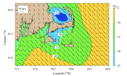
10:00 PM, January 26, was around the time of the last e-mailcommunication between the Lady of Grace and Lisa Ann II. The map of themodel-predicted near-surface wind and air temperature over Nantucket Sound atthat time showed that a strong northwesterly wind with speeds increasing togreater than 10 m/s occurred in Nantucket Sound, withair temperatures below -20 oC near the Cape Cod coast (see Figure1).
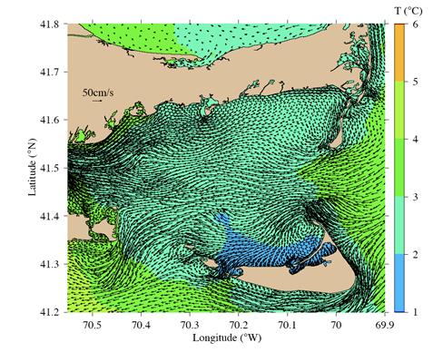
At this time, the tide was near the ebb-flood transition period,with relatively strong currents of greater than 0.5 meter per second rushinginto Nantucket Sound through the Nantucket Island/Cape Cod passage and flowingout through the Martha’s Vineyard/Nantucket Island passage and through VineyardSound. The surface currents inside the Sound were dominated by westward flowwith speeds of 0.1-1.0 meter per second (Figure 2). Two hours later the currents werereversed. Except near NantucketIsland, surface water temperatures in Nantucket Sound were generally between2-3 oC, with warmer temperatures downwind from Nantucket.
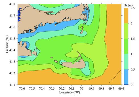
The model-predicted significant surface wave height Hs distribution at 9:00 PMJanuary 26 predicted using the SWAN (Simulating Waves Nearshore) was from lessthan 0.5 m near Cape Cod to 1.0-2.0 m north of Nantucket and exceeded 2.0 mfurther downwind (Figure 3).
These models predict rough weather and ocean conditions in NantucketSound on the night of January 26. In the 1980’s, NOAA researchers developed ageneral algorithm for estimating vessel icing at near-freezing sea surfacetemperatures in Alaskan waters (Overland, 1990). The icing rate depends on wind speed (![]() : m/s), air temperature (
: m/s), air temperature (![]() : oC), sea temperature (
: oC), sea temperature (![]() : oC) and freezing point of seawater (
: oC) and freezing point of seawater (![]() ), with a predictor (PR)given as
), with a predictor (PR)given as
| (1) |
Based on this predictor, the icing rate can be divided into four classes: 1) light (PR <20.6 moC/s); 2) moderate (20.6 < PR < 45.2 moC/s);3) heavy (PR > 45.2 moC/s); and 4) extreme (PR > 70.0 moC/s) (Overlandet al., 1986). The icing rates incm/hr for the first three catalogs (light to heavy) are less than 0.7, between0.7-2.0, and greater than 2.0, respectively. Overland (1990) pointed out that “for small fishing vessels (20 m) proceedinginto waves at typical speeds the wind speed for moderate icing is sufficient toprovide spray to forward deck areas“.
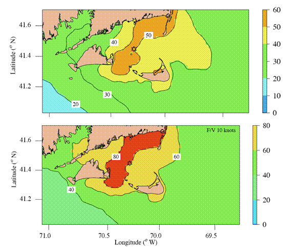
Using the model output, we calculated the icing rate predictor PR over Nantucket Sound (based on afreezing point of seawater at -1.7oC) for the period January 25-29. While the expression for PR has not be verified in New Englandwaters and does not include the effects of surface waves explicitly, theestimated PR during the night ofJanuary 26 predicted that the Lady ofGrace was steaming into waves in an area with mid-moderate up to heavyicing rates (with PR in the range of35-45 moC/s and icing rate of greater than1.5 cm/hr) (Figure 4). This model prediction is consistent with the report fromthe Lady of Grace about serious icingon the vessel.
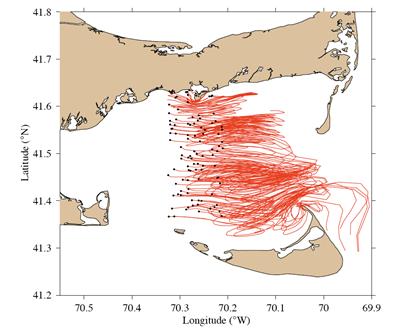
After the Lady of Grace was reported missing, the Coast Guard conducted 17 separate searches thatcovered Nantucket Sound and surrounding waters. Figure 5 shows the results of amodel simulation of 100 surface drifters randomly deployed in a south-northzone across Nantucket Sound at 10:00 PM January 26 and tracked for 18 hours.The trajectories of these “model” surface drifters clearly show a tendency tomove eastward. This suggests that if the Ladyof Grace lost power, it should drift to the east. Since the vessel waseventually found in Cross Rip Shoal, it suggested that the Lady of Grace sank quickly when icing occurred after it moved intothe high icing rate and surface wave zone in Nantucket Sound.
This re-analysis of the marine weather and ocean conditions inNantucket Sound and surrounding waters during January 25-29, 2007, suggeststhat the coupled atmosphere/ocean model system developed at UMASSD was capableof predicting surface icing conditions for fishing vessel application. Inspring 2008 with support from the Northeast Regional Association of CoastalOcean Observing Systems, the coupled UMASSD system (named NECOFS (NortheastCoastal Ocean Forecast System) was upgraded and transitioned into a 24/7operational system providing 3-day forecasts of the surface weather and oceanconditions for the Northeast region. Model forecast data for surface icingconditions are being sent to the NOAA NWS Weather Forecast Office in Taunton,MA.
Thisreport was prepared by C. Chen and R. Beardsley with input from other membersof the reanalysis team.


