

NECOFS
NECOFS, the Northeast Coastal Ocean Forecasting System, is an advanced high-resolution, global-regional-coastal coupled weather/waves/ocean-river model system designed to 1) integrate real-time observations to produce accurate forecasts of the coastal ocean environment for the storm-induced coastal inundation early warming, ocean rescue and safety, marine operations, and 2) assess the climate change impact on coastal hazards resiliency, regional water quality, and ecosystem. The NECOFS operation is supported by the Northeastern Regional Association of Coastal Ocean Observing System (NERACOOS).
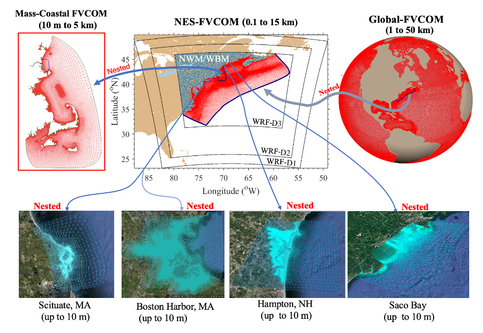
The present system includes 1) a community mesoscale meteorological model named “Weather Research and Forecasting (WRF-AWR)”; 2) the global-regional nested ocean model (NES-FVCOM/Global-FVCOM) (Chen et al. 2003, 2016); 3) the unstructured-grid surface wave model (FVCOM-SWAVE) modified from SWAN (Qi et al., 2009) with the same domain as NES-FVCOM; 4) the Mass Coastal FVCOM with the inclusion of estuaries, inlets, harbors, and intertidal wetlands; 5) the National Water Model (NWM)/Water Balance Model (WBM), and 6) four subdomain wave-current coupled FVCOM inundation forecast systems in Scituate, MA; Boston Harbor, MA; Hampton-Seabrook Estuary, NH, and Saco Bay, ME (Chen et al., 2021) (Fig. 1).
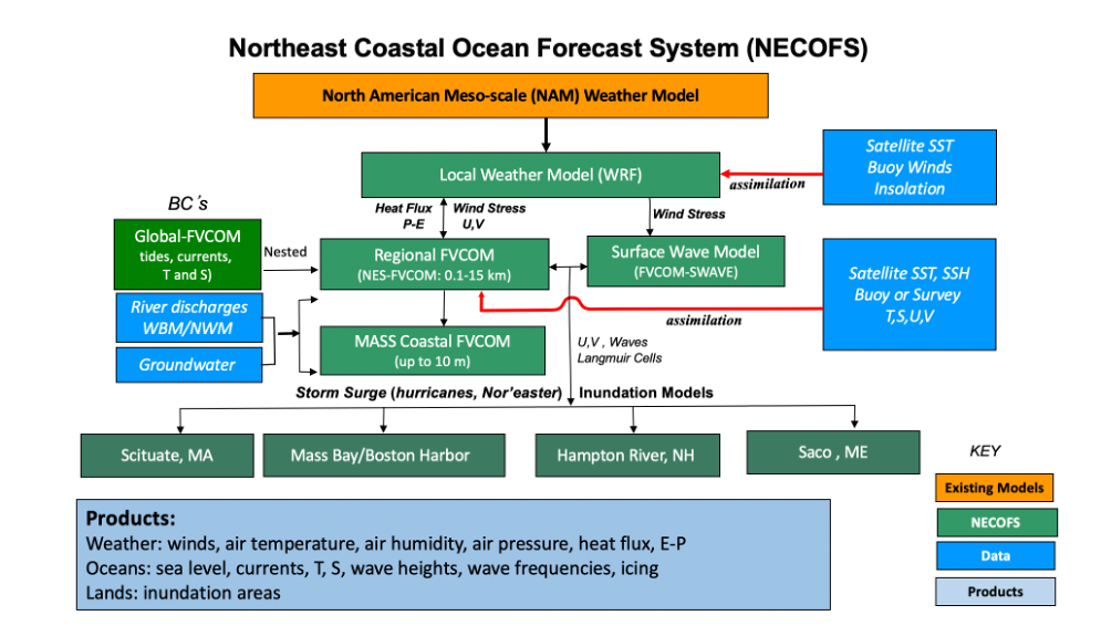
The FVCOMs in the NECOFS are the fully three-dimensional (3D) unstructured-grid models configured with non-overlapped triangular meshes (Fig. 2). The mesh resolution varies from 0.5 to 50 km in Global-FVCOM, 0.1 to 15 km in NES-FVCOM, 10 m to 5 km in Mass Coastal-FVCOM, and up to ~10 m in four inundation models. The inundation model uses the high-resolution (1-m´1-m) LIDAR bathymetry data, including the land and water. Both WRF and regional ocean models are configured with 45 layers in the vertical. The hybrid coordinates are specified for Global-FVCOM, NES-FVCOM, and Mass Coastal-FVCOM. The s-coordinate is chosen over the slope and deep basins to have horizontally uniform thin layers near the surface and bottom for better resolving the surface mixed and bottom boundary layer. The -coordinate is adopted in the shallow coastal and estuarine areas to connect inundation models. Coastal inundation is simulated using a 3D wet-dry treatment method in FVCOM (Chen et al., 2008), which was validated for wetland-estuarine-shelf water exchange in the Satilla River, GA (Chen et al., 2008), the Okatee/Colleton River, SC (Chen et al., 2022), the Plum Island Sound-Merrimack River complex, MA (Zhao et al., 2010), Scituate Harbor, MA (Beardsley et al. 2013, Chen et al., 2013), and tidal simulation in the Gulf of Maine and Mass Bay (Chen et al., 2011). The resolution for WBM and NWM are 2.0 and 1.0 km, respectively.
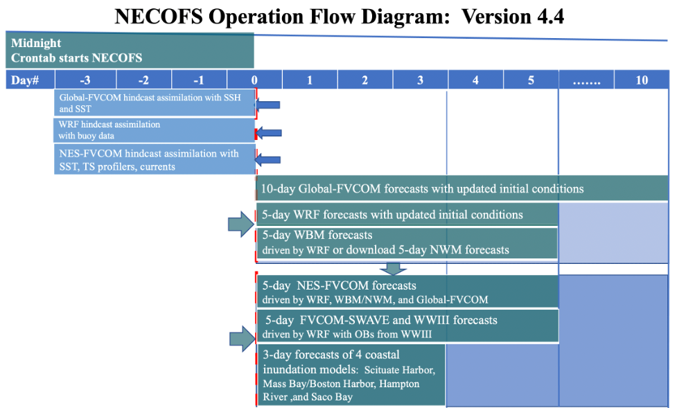
NECOFS was placed in experimental 24/7 forecast operations in late 2007. NECOFS has demonstrated the capability to forecast weather, surface icing, surface waves, water level, ocean hydrographic (temperature and salinity) conditions, ocean currents, and storm-induced coastal inundation over the U.S. Northeast. NECOFS is being operated by both forecast and hindcast modes. The forecast period covers 10 days for Global-FVCOM, 5 days for WRF, NES-FVCOM, Mass Coastal-FVCOM, and 3 days for coastal inundation models. The forecast operation starts at midnight daily, first to conduct 3-day backward hindcast assimilation to integrate NERACOOS and NOAA buoy data to update the initial conditions for WRF and NES-FVCOM, then to make a 5-day forecast for the weather and oceanic conditions. Recently, NECOFS has been upgraded by adding a 5-day forecast of river discharges from the Water Balance Model (WBM) or National Water Model (NWM) to improve the land-river-ocean interaction. The forecast fields are posted at the NECOFS web map server and the NERACOOS website.
Meanwhile, the hindcast simulation was conducted starting on January 1, 1978. The results were validated by comparing the results with many available observations, including 1) water levels at tidal gauges, 2) temperature and salinity in the water column and 3) the currents derived by CODAR and recorded on NERACOOS moorings. NECOFS was also validated for the storm-induced surges and coastal inundation by hindcasting flooding caused by the extratropical storm (nor’easter) that swept the NES on December 27, 2010 (Chen et al., 2013b; Beardsley et al., 2013), the storm surge caused by the 1991 Hurricane Bob (Sun et al., 2013) and the CODAR comparison in Block Island South and adjacent coastal and shelf regions by Sun et al. (2016). This dataset was used to reanalyze the storm-induced coastal inundation in the northeastern region and examine the impacts of sea-level rise on future storm-induced coastal inundation (Zhang et al., 2020; Chen et al., 2020).


